The Sierra Gorda Biosphere Reserve emerged from a presidential decree granted on May 19, 1997 with the purpose of protecting the Reserve’s exceptional richness of species and ecosystems. The Reserve is managed by the National  Commission of Natural Protected Areas (CONANP) of the Ministry of Environment and Natural Resources (SEMARNAT) and is located in the northern part of the state of Querétaro between 20° 50´ and 21° 45´ latitude north and 98° 50´and 100° 10´ longitude west.
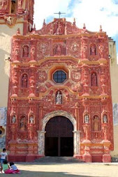
Five XVIII century Franciscan missions were designated as UNESCO World Heritage sites in 2003 and are located within the beautiful natural environment of the Sierra Gorda Biopshere Reserve which is a member of the Man and Biosphere Programme of UNESCO since 2001.
The Biosphere Reserve covers 383,567 hectares of the state of Querétaro, representing 32 percent of the state’s territory. The Reserve contains 11 core protected areas that cover 24,803 hectares and a buffer zone with 358,764 hectares. The Reserve contains all of the municipalities of Jalpan de Serra, Arroyo Seco, and Landa de Matamoros, as well as 88 percent of Pinal de Amoles and 70 percent of Peñamiller. The Reserve has approximately 100,000 citizens living in 638 localities.
The principal biological characteristic of the Sierra Gorda is eco-diversity. It is unique for its large number of distinct ecosystems with high diversity of life forms. For biodiversity, it is one of the most richest, best-conserved and diverse sectors of the state of Querétaro, and stands out for its level of conservation in comparison with neighboring regions and states.
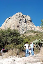
Among all the natural protected areas in Mexico, the Sierra Gorda Biosphere Reserve occupies first place for its eco-diversity due to its geographic position at the meeting point of the Nearctic and Neotropical bioregions. The Reserve presents great physiographic complexity, with altitudes ranging from 300 meters above sea level in the canyon of the Santa María River in the municipality of Jalpan de Serra to 3,100 meters above sea level at the summit of the Cerro de la Pingüica, found in the municipality of Pinal de Amoles.
This physiological complexity, combined with a heterogeneous precipitation pattern, ranging from 350 to 2,000 mm per year, generates numerous climate variations. The strong variation in rain patterns is a result of rain shadows created by the mountain ranges of the Sierra Gorda.
The Sierra Gorda belongs to the Pánuco River basin via the Santa María and Moctezuma rivers, which in turn are fed by the Escanela, Tancuilín, Extoraz, Ayutla and Concá rivers.