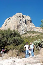
The archaeological sites of Ranas and Toluquilla, north of the state of Queretaro and south of the Sierra Gorda is located in a wooded area in an ecological niche that goes from the northwest to the southeast of the Sierra. This niche has great elevations of more than 3 000 m used parteaguas or barrier for the winds coming from the Gulf of Mexico, which makes the fog predominates and development of coniferous forest and oak.
This environment is surrounded to the east, west and south by low hills to experience the rain shadow effect, as the water falls in the high mountains, so little rain and generates a system of semi, with vegetation of cactus and low thorny bushes.
Most of the mountain is composed of limestone rocks with geological faults that allow the accumulation of minerals such as mercury, lead, zinc, silver, gold and small amounts of copper and arsenic. In pre-Hispanic times exploited the iron oxides, which appear as red soil, known as raddle and red mercury sulfide, maroon or locally known as cinnabar. These products, used as pigments in ancient times, were located in underground mines in operation and open skies.
History
Sierra Gorda is located north of the state of Querétaro is part of the Cordillera de la Sierra Madre Oriental that runs parallel to the Gulf of Mexico. This large area covers part of the states of Hidalgo, San Luis Potosi, Guanajuato and Queretaro, and in the latter, the municipalities of Arroyo Seco, Pinal de Amoles, Jalpan Serra, Landa de Matamoros, San Joaquin and Peñamiller.
Recent studies indicate an age of between 6000 and 4000 years for the earliest human occupation of the south of the area. The Sierra Gorda was an area of intense cultural and commercial traffic to the coasts of the Gulf, the Huasteca and the bureau of central Mexico mainly, but traces have been found to account for trade with the regions of Rio Verde (San Luis Potosi) , Teotihuacan, Tula and the West of Mexico, the area of the Bajio, the valleys of Querétaro and San Juan del Rio.
Through analysis of the pictorial features found in the area, it is clear that nomadic hunter-gatherers and sedentary groups which wholly or partially dependent on agriculture were in frequent cultural exchange.
The contacts between people and cultures surrounding mountains were heterogeneous, as are local features, identity politics and the exploitation of mineral resources. For the period between 200 and 1000 AD, the Sierra Gorda has been classified into three regions: Rio Verde, and Sierra Huasteca culture, which inhabited groups own cultural identities.
The region of Rio Verde is located northwest of the state of Queretaro and their settlements were in the height of 1200 meters. Culture in the region of mountain settlements are located and Las Ranass Toluquilla, which are located in the upper parts of mountains, dominated the natural passes and controlled the mineral resources and the movement of goods. La Huasteca region covers the northeastern part of the state and among their settlements out Tancoyol, La Campana, Tancama and Tonatico, who controlled the fertile land in the valley and the middle slopes.
Upon arrival of the Spaniards, the land was inhabited by highland groups jonaces, Huastecos, and ximpeces Pamesa. Of these, the jonaces out for their ferocity and those who were involved in the controversial war Crescent, in 1749, which represents the end of attempts to pacify the area Chichimecas. Apparently, this famous war mitificó. Domain which was common on the hill called La Media Luna, located along the road to Jalpan in the area of the semi, there was a "final battle" between groups Chichimecas with the Spaniards and their native allies. It was said that when they saw the lost battle, whole families of Chichimecas be winnowed from the top of the walls of rock that stand out in a collective suicide attempt, highlighting their cultural integrity.
The Lakers (or xi'oi as themselves) were the most widespread and were peaceful and emotions to work and trade with the Spaniards. Who were gathered in greater numbers around the missions and worked with them the Franciscan longer. At present there are groups in the municipality of Pamesa Jalpan and the delegation of Tancoyol, mainly in the New Las Flores.
CHRONOLOGY
Pre-Hispanic times
Early settlers. Cadereyta in the south of the mountains in the area of Leon officers, they have found projectile points and Coxcatlán Tilapa rates, that indicate a human presence between 6000 and 4000 years of antigüedad.Clásico (200-900 AD) . The area is inhabited by the "mountain", which extracted cinnabar to trade with Teotihuacan.
800 A.D. By this time arriving in the region Otomí, which peacefully coexist with the groups that inhabited it.
Post (900-1521 D.C). The gradual drying of the area prevents the development of agriculture. Las Ranass, Toluquilla, and Quirambal The Soyatal are abandoned.
Colonial
1527. Nuño de Guzmán Oxitipa conquest of the manor, which belonged Jalpan, Xilitla, and Tancoyol TILAC.
1550. Missionary activity begins in the Sierra Gorda with the founding of a mission into Agustina Xilitla, San Luis Potosi.
1554. War begins with Chichimecas, considered a danger to the movement toward real mines, such as Zacatecas.
1676-1677. Working in the Augustinian missions Jalpan Conca Barranca and agree with the Franciscans.
1682-1683. Since the mission Maconí, head of the Sierra Gorda, the captain of Jerome Labra toward the site of Las Ranass and founded the missions of San Nicolas de Tolentino, Nuestra Senora de Guadalupe de Deconí, San Juan TETLA, San Francisco Tolimán, The Nopaleda, and Santiago del Palmar San Jose del Llano. After the death of De Labra, the missions remain unprotected.
1700. By this time, Dominicans and Augustinians abandon missions and they are left to the Franciscans to preach in Tolimán years ago, Cadereyta, Escanela and Maconí.
1740. Franciscans founded their first mission in San José de Vizarrón.
1744. On April 20, Father Pedro Pérez de Mezquía founded Franciscan mission in Santiago, Jalpan.
1750. Fray Junipero Serra's mission reaches Jalpan.
1751-1762. Construction missions of Santa Maria del Agua de Landa, San Miguel Conca, San Francisco del Valle de TILAC and Our Lady of Light Tancoyol.
1784. Father Junipero Serra died at age 70 after 34 years of missionary work, 11 of which were devoted to the noble and formidable task to achieve, in the company of Fray Francisco Palou, integrating spiritual, cultural, social and production of the indigenous people of the region. Today the municipality of Serra Jalpan is named in honor of the missionary.
XIX Century
1810. The revolutionary movement strongly influences the mountainous area and there are several armed uprisings.
1819. The population of Jalpan left in ruins after it was burned and ransacked by the army realistic.
1857. Since Jalpan, General Tomás Mejía undertakes continuous military actions against the Liberal Party, which ruled the state of Queretaro and the Republic, until the taking of the Plaza de Querétaro.
1880. The construction of an unpaved roads linking the capital of the state represents a strong impetus to economic development in the region.
XX Century
1904. The state governor, Francisco Gonzalez de Cosio, gives the villa Jalpan category city that already had telephone service (from batteries), power-based carbide, telegraph, as well as milling of sugar cane.
1911. Is created in Jalpan Aquiles Serdán Revolutionary Group, commanded by Mr Polycarp Olvera, who is under the command of Don Francisco I. Madero.
1962-1970. Thanks to efforts of Manuel Gonzalez de Cosio, governor of Querétaro, Querétaro is built road-Jalpan. It was also built roads and bridges, and introducing electricity services and water.
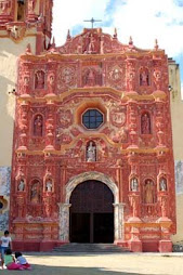
2003. UNESCO declared World Heritage Site to the Franciscan missions of Sierra Gorda of Querétaro.
The mission of San Francisco Tolimán was founded in 1683.
La Presa Jalpan is of global importance because of waterfowl habitat.
Coniferous forest, rich cypress, ocote, pines and junipers.
Among the many highlights of rivers Jalpan, Ayutla, Santa Maria and Extoraz.
PRACTICAL INFORMATION Getting There
In the Sierra Gorda queretana can be accessed by the federal highway No.. 120 San Juan del Río-Xilitla, which is taken, if you come by the Mexico-Queretaro highway, at the height of San Juan del Rio.
From the city of Mexico, the North Terminal, leaving three runs buses to Xilitla, passing through various towns in the mountains. Also at the Terminal de Autobuses de Querétaro there are several races throughout the day to several mountain villages and two runs in first-class service to Jalpan Serra.
Jalpan is popularly known as the "heart of the Sierra Gorda," a metaphor that has its related real with all the services of a small Mexican town, two banks, variety of accommodation, a museum and historical center and managed care, which make your stay pleasant and safe, plus all the weekends are held in the artistic presentations of the main garden kiosk.
The neighboring state of San Luis Potosi is reached for the interstate highway No.. 57, which connects the town of Arroyo Seco with the Rio Verde Potosina population, with bus service to Jalpan several times. In the capital there are two straps Potosina Jalpan Serra.
Las Ranas
The archaeological site of Las Ranass is located in the southwest of the Sierra Gorda. You get to the site by the federal highway No.. 120 San Juan del Río-Xilitla; going population Vizarrón, seven miles below San Joaquin is the archaeological area and later. This site is located 154 km northwest of the city of Queretaro.
Inhabited between VII and XI centuries, Las Ranas was one of the cities with the highest cultural development between the peoples of the region due to the extensive trade which provided both to the coast of the Gulf of Mexico and to the Altiplano. The mining of cinnabar (red pigment in great demand among the Mesoamerican peoples) was one of the main economic activities, along with seasonal agriculture.
The characteristics of the buildings indicate the existence of a stratified society. The people used materials from the region and mixed stone flagstone and mud, the floors were packed with earth or stucco siding. The urban development reflects an important advantage of the irregular terrain of the mountains. Las Ranass was invaded by peoples from the north Chichimecas mainly jonaces, and when the Spaniards arrived in the region was uninhabited.
Toluquilla
The archaeological site is located 110 km northwest of San Juan del Rio. It is reached by State Highway No.. 120 San Juan del Río-Xilitla reaching Vizarrón 7 km forward is located 27 km and San Joaquin toward Maconí, take the turning on the Hope Ranch, to find the gap that leads to the archaeological site.
Toluquilla ( "Hill of Jorobadillo") is located on the plateau of the hill which takes its name. Upon arrival the Spaniards was uninhabited, like his contemporary Las Ranass. Toluquilla it was smaller and reached its peak around the ninth century. Long-established important trade ties with Teotihuacan, Tula and the Huasteca, and along with Las Ranass, controlled the trade of mercury and cinnabar.
Constructive Toluquilla shares many characteristics with other cities in the Sierra Gorda, mainly Las Ranass. It was common to use flagstone stone, clay and stucco, and had an efficient use of landfill sites by allowing extensions and leveling the ground to suit the needs of growth. With a stratified social organization, the decline took place between Toluquilla xy xi century as part of the phenomenon of social maladjustment of the whole area. Hours: Monday through Friday, 9:00 to 17:00 hr. Services: custodians.